
Where is the wave
The Wave is located in the Coyote Buttes North Special Management Area, which is located within the Paria Canyon/Vermilion Cliffs National Monument. This land of geological and scenic wonders is overseen by the Bureau of Land Management (BLM) and straddles the border of Northern Arizona and Southern Utah. An advance permit is required to hike to The Wave, and with a mere 20 people per day allowed to visit, it’s common knowledge that this has become one of the most coveted hikes in the American Southwest. What isn’t common knowledge is that getting a permit is one of several challenges would-be hikers might encounter when planning their trips to this area.
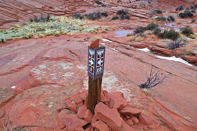
Coyote Buttes North and The Wave are situated due East of the House Rock Valley Road (HRVR), a dirt track that connects US89 East of Kanab, Utah to US89A East of Jacob Lake, Arizona. Access from the HRVR is via a 2.6 mile (one-way) hike on the Wire Pass Trail.
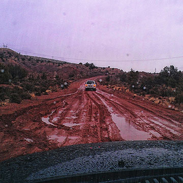
While the House Rock Valley Road is well-maintained and drive-able most of the year, there are instances where the road can be rendered virtually impassable. This is usually after a severe weather event, such as a winter snowstorm, or flash flood, which usually accompanies late summer monsoon storms. Knowing what you’re getting into before driving down this road is imperative to the success of your trip, so check with local officials before rubber leaves (paved) road. This is particularly important if you’re in a rental vehicle since off-road driving is technically prohibited, and any damage sustained by doing so will void your insurance policy and leave you liable for any repairs, towing, or associated expenses.
If you learn that the HRVR is in questionable condition, and you prefer not to get your rental vehicle stuck in the mud or someplace else precarious, you have a few alternatives, the obvious one being to scrap your trip plans and try again for a permit (and all that that implies) another time.
Another one would be to Hire A Guide authorized for Coyote Buttes North, who are usually equipped with vehicles that are able to slog through deep mud or sand and spider-crawl over large boulders and ruts with relative ease, and see if they can get you to the Wire Pass Trailhead (and back).
Weather can make the road impassable!
14 Responses
Hi SMP,
In terms of mileage, the nearest hotel accommodations to The Wave are in the town of Big Water, UT, which is ~30 miles from the Wire Pass trailhead. There is a Rodeway Inn property there.
Otherwise, you’ll find the biggest selection of accommodations in Page, AZ, or Kanab, UT. Either town is ~1 hour drive from the Wave trailhead, and offers ample selections of traditional hotel or motel-style lodging as well as vacation rental homes in price ranges and amenity classes ranging from Motel 6 to Marriott and everything in between. For more information on what’s available, click on the links below:
Book a hotel in Kanab, Utah
Book a hotel in Page, Arizona
If you require further assistance, please contact me directly at [email protected]
Good luck and safe travels,
Alley 🙂
Where is the nearest accommodations to stay near the Wave?
Hey Johanne –
Congrats on scoring that permit! (You did get a permit, right?)
February can be a great time to hike the Wave, it can also be tricky depending on the whims of Mother Nature.
February is winter. That means it will most likely be cold with average daytime highs in the 40’s or 50’s and overnight lows in the 20’s and 30’s. While many days are sunny and brisk, the occasional rain or snowstorm is known to occur. Or you might even be lucky enough to experience a glimpse of “Strawberry Spring” where you can comfortably ditch the fleece and long pants and do the hike in shorts and shirtsleeves. Naturally, it’s too soon to know at this point. I recommend you start monitoring Grand Canyon East weather about 2 weeks out using Page, AZ, or Kanab, UT, as your search point. Best case scenario, plan on dressing in light layers that you can easily remove as the outside air and your core temperature warms up. Any time of year, a wide-brimmed hat, sunglasses, and sunscreen are a must to have in your pack. Good walking shoes that are already broken in should also go on your packing list.
Upon arrival in the area, check conditions of the House Rock Valley Road. If recent weather has brought any precipitation, it may be impassable to 2WD vehicles. The Page-Lake Powell Hub or the Kanab CVB office should have current information.
Hope that helps! For more information, trip reports, etc., please join our Facebook group devoted to Coyote Buttes North and the surrounding area, The Wave AZ Group
Good luck and safe travels,
Alley 🙂
Hi Alley, my girls friends and I are the lucky ones to do The Wave on next february. What we should expect for the temperature ? What do we will need in the backpack?
thanks ! and can’t wait to go there ! and meet you maybe ??!!
Hi RS,
The closest towns to The Wave are either Kanab, UT, or Page, AZ. The difference in distance between the two is pretty much negligible, so either would be a good place to stay for your Wave hike.
As for tour companies who can get you out there, and offer pick-up from Kanab, UT, and Page, AZ, there are several based in both towns, and one based in-between. For more information on them, read “Hire A Guide To The Wave” Note the article lists ~a dozen companies, all licensed and well-rated for safety and service. The companies we are personally most familiar with are Dreamland Safaris out of Kanab, UT; Vermillion Adventures out of Page, AZ; and Paria Outpost & Outfitters in Paria, UT.
Good luck and safe travels,
Alley 🙂
Hello, is Kanab the closest town to stay in? Could you please suggest a tour comapny that will pick up from Page and also from Kanab? Trying to explore all options, already have permit for 2.
Hey Julie!
Congratulations on scoring that Wave permit. Sorry that 7 was not a lucky number in this case, however.
The good news is that the “losers” — if you want to call them that LOL — have a plethora of choices of areas they can visit that are just as beautiful, or dare we say it, even more so! Our favorite Wave alternative is White Pocket. About 5 miles due East of Coyote Buttes South, the scenery is absolutely amazing, you don’t need a permit to get there (not yet, knock on wood) and the hiking involved is very easy. The only downside to this area is the difficulty of driving in. The access road is VERY sandy, and people unaccustomed to 4-wheel driving conditions get stuck out there a lot. Due to the remoteness of the area, cell service is very spotty and help will be a long time coming, not to mention VERY expensive. Therefore, we recommend that those who wish to visit White Pocket go with a guided tour. There are several licensed companies offering this service, but the ones we are most familiar with are Dreamland Safari Tours in Kanab, UT (~1 hour from La Verkin), or Paria Outpost located between Page, AZ, and Kanab, UT, on US89 (~90 minutes from La Verkin). Of the two companies mentioned, Paria Outpost is closer to the House Rock Valley Road, where the trailhead for The Wave is located (map), so that might be a good post-hike meet-up spot.
As for what kind of weather to expect in early June? In a word, HOT, HOT, HOT~ OK, that’s 3, but that’s essentially it. So, make sure you get an early start on your day. The crack of dawn is not too soon to hit the trail to take advantage of cooler temperatures. Regardless, bring plenty of water, sunscreen, hats, and electrolyte replacement to compensate for the nutrients you’ll lose through sweating. I was partial to Gookinaid powder back in the day, which is now marketed under the name Vitalyte. I’ve also heard good reports on Nuun tablets, but have never used them.
Good luck and safe travels!
Alley 🙂
Hello!
The good news is…we won The Wave permit for 6 for our June 2022 trip!! The bad news is…there’s 7 in our group coming from Wisconsin. So we decided to send 5 to hike The Wave and the other 2 to find an alternative hike in the area. Any suggestions for the 2 losers? Also, we’ll be in one vehicle driving from La Verkin so we’ll want to be fairly close to pick up The Wave winners. 🙂
Also, what temps should we expect for early June??
Thanks so much!
Hey MJ,
The Wave is located about 1 hour’s drive from the town of Page, AZ, which is ~a 4.5 hour drive from Scottsdale. Since the hike is essentially an all-day affair, you should stay overnight in Page, AZ, or Kanab, UT the night prior to your hike (these are the nearest towns with hotels).
Hope that helps! Good luck and safe travels,
Alley 🙂
http://horseshoebend.com
http://antelopecanyon.az
http://thewaveaz.com
http://antelopecanyonboattours.com
http://alstrompoint.com
http://towerbutte.com
http://canyonskywalk.com
How far away is this from Scottsdale? Thank you.
Hi Kat,
Late September-mid October are generally regarded as the best time to visit the American Southwest! For hiking to The Wave specifically, that period extends into early November when temperatures are cooling down enough to make the hike, which is almost completely exposed to the sun, bearable. The downside is that time of year is also the most competitive for applying for permits, so you’ll have literally hundreds of people vying for a mere 20 spots.
Good luck, safe travels, and Happy Holidays to all,
Alley 🙂
Hi Dorit,
The hike to/from The Wave is approximately 6 miles in length. It is considered “moderate” on the degree of difficulty scale, but some parts requiring some uphill climbing can be taxing. Fortunately, these are relatively short in comparison to the hike as a whole.
Good luck and safe travels,
Alley 🙂
hi
how long and what is the difficulty of walking to and in the wave? Assumed that we take you as a guide?
What months are the best months weatherwise