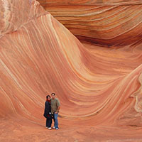
Michaelangelo took 2 years to sculpt the statue of David. Leonardo da Vinci spent 4 years painting the Mona Lisa. Mozart could write an entire opera in less than 6 weeks! Yet these works of art don’t hold a candle to one sculpted by the forces of wind and water, and lots and lots of time: The Wave. One look at The Wave, a small section of the Coyote Buttes North Special Management Area in the Paria Canyon/Vermillion Cliffs Wilderness, and you might think you’re on another planet. The rippling symmetry of line, the myriad variations of earth tones of brown, beige, yellow, pink and maroon, and the quizzical, gravity-defying rock formations surrounding it surely cannot be of this world! And yet, they are, straddling the border of Northern Arizona and Southern Utah.
"The Journey Rivals the Destination"
Melisa S.
Hiker
How was it made?
So, what is The Wave and how did it get here? The Wave is a real-life “Jurassic World.” This unique cluster of U-shaped troughs began as sand dunes, which eventually compacted and solidified into sandstone over 200 million years ago. The troughs were then carved into Navajo sandstone by intermittent streams and floods, whose run-off deposited minerals such as calcium, manganese and iron oxide, while simultaneously eroding the rock along its joints, gradually molding them into their gently rounded appearance.
The process of water erosion eventually tapered off, allowing wind and blowing sand to do the bulk of the work in sculpting The Wave into its present form, exposing large deposits of cross-bedded sandstone marked by rhythmic and cyclic alternating grainflow and undulating laminae (a thin layer, plate, or scale of sedimentary rock, organic tissue, or other material). In some areas, the Wave exposes deformed laminae within the Navajo Sandstone. These laminae were deformed prior to the timeframe when sand turned into to stone, which is indicative of the trampling, churning and digestive processes of dinosaurs!
The forces that created The Wave were time-consuming, complex, and fortuitous. Indeed, it was one of those rare instances when the elements were in the right place at the right time together, and the results are absolutely exquisite. It stands to reason that this area is unique in all the world. It is also ecologically fragile, and warrants as much protection as the law will allow. That’s why only 20 people per day will have the good fortune to see The Wave and Coyote Buttes North up close and personal by acquiring an advance hiking permit from the Bureau of Land Management, the federal agency that oversees these areas. Those with adequate determination, and deep pockets, may also charter an airplane or helicopter over Coyote Buttes and The Wave from Kanab, Utah or Page, Arizona. Get A Hiking Permit For The Wave
Hi Laurie,
The trail to the Wave is out-and-back, so yes, you must hike the entire 6 miles if you wish to see The Wave.
All hikers are required to obtain a Coyote Buttes North hiking permit, even those who are hiking solo.
Hope that helps. Please contact us at [email protected] if you have other questions.
Good luck and safe travels,
Alley 🙂
Hi Rachel,
You should definitely be physically fit before attempting to hike to The Wave.
At 6 miles round-trip, it is considered moderately challenging according to AllTrails. While the walk itself is not inordinately hard, the environment definitely can be. Particularly during the warmer months of late spring, summer and early fall, daytime temperatures can exceed 105 degrees Fahrenheit. Adequate food and water must be carried to prevent dehydration, heat exhaustion, and heat stroke. 1 gallon per person is not too much according to many who’ve successfully made the trip.
Should you need medical attention, it is available, but since backcountry rescues typically involve life flights by helicopter or long ambulance rides, such assistance will come at a high cost.
If you doubt your ability to hike The Wave, or your luck with the highly competitive permit process, another way to see it is to fly over it. Fixed-wing airplanes and helicopters can be chartered out of the Page Municipal Airport. While you would not land at The Wave, you would still see a ton of incredible scenery in addition to The Wave in a relatively short amount of time. For more information on flying over The Wave, visit “So You didn’t Get A Wave Permit – Now What?”
If you have further questions, please contact us directly at [email protected] or [email protected]
Good luck and safe travels,
Alley
Dear Youngjoo,
You don’t make a “reservation” to visit the Wave.
You must obtain a hiking permit for the area known as Coyote Buttes North through one of two lotteries conducted by http://www.Recreation.gov: the advance lottery, which would be held in April for the month of August, or the in-person lottery, which you’d enter 2 days prior to your desired hiking date by downloading Recreation.gov’s app on your smartphone and following instructions for Coyote Buttes North. For the in-person lottery, you would physically need to be within a certain radius of the towns of Page, AZ, or Kanab, UT.
Only 64 people per day are allowed to enter Coyote Buttes North. 48 permits are given out in the online lottery, 16 in the in-person lottery.
Since the probability of you obtaining a permit for The Wave are statistically very low, we strongly recommend making alternate plans now for touring other sites that area just as scenic but don’t require a permit. The Alt Wave Adventure with Kanab Tour Company would be one possibility, as would White Pocket, Soap Creek, Sidestep Canyon, the New Wave, Wire Pass Canyon and/or Buckskin Gulch.
Should you really have your heart set on seeing The Wave at any price, you might consider chartering a plane or helicopter out of the Page Municipal Airport. Yes, this would be a pricey way to go, and neither aircraft would land at The Wave, but you would see a ton of incredible scenery in a relatively short amount of time. For more information, visit our partner site, TheWaveAZ.com: So You Didn’t Get A Wave Permit – Now What?.
Good luck and safe travels,
Alley 🙂
Thank you for all of the information and websites. The wave is one of my dream places to visit but so far, I haven’t had luck to win the ticket to go. Hopefully someday soon I can get to see The Wave.
Dear Grant,
Keep trying – persistence pays off! If one day you get tired of applying and applying to no avail, you might consider flying over The Wave. Fixed-wing airplanes and helicopters depart out of the Page Municipal Airport daily, weather permitting and possibly contingent on a certain number of passengers traveling. Mornings are the best time to fly for optimal light, lack of wind, and minimal disturbance to the hiking community. Yes, this would be a pricey way to go, but you’d be guaranteed of seeing The Wave, along with a ton of other great scenery!
For more information, check out “TheWaveAZ.com: So You Didn’t Get A Permit – Now What?”
Good luck and safe travels,
Alley 🙂
How strenuous is the hike? Are you hiking in sand? Is it a hike down and a return hike up? If a hike down what is the relative incline? Any cell phone service?
Hi Karen!
While the hike to The Wave is rated “moderately challenging” according to AllTrails.com, it is not an adventure to be taken on lightly or ill-advisedly. The roundtrip distance of 6+ miles makes it pretty much an all-day commitment. The hike into the Coyote Buttes North area via the Wire Pass Trail is partially through a dry wash, which may offer up deep “sugar” sand depending on recent weather conditions. There is also a bit of an uphill climb over a ridge involved to get to The Wave itself. As for the degree of incline, that I have no idea about. You might watch this video to get a sense of the general hiking conditions, degree of difficulty, etc. You can also find more detailed information on TheWave.info. As for cell phone service? Spotty to non-existent. Don’t count on being able to use it if you were to encounter trouble.
All that said, the most difficult aspect of getting to The Wave is acquiring the required hiking permit. The majority of permits (64 in all) are given out through an online lottery held 4 months in advance through Recreation.gov. Last-minute permits are dispensed 2 days prior to your desired hiking date, also via Recreation.gov, but you’ll need to download their app onto your smartphone or other mobile device to take part in that. Applications for the in-person permits are only permitted within a certain area monitored by a geofence, so you should be staying in Page, AZ, Kanab, UT, or other community nearby.
If the prospect of the hike and/or the difficulty of the permitting process prove insurmountable, another possible way to see The Wave is to fly over it. Fixed wing airplanes and helicopters depart out of the Page Municipal Airport daily, weather permitting, and possibly contingent on a certain number of passengers traveling. Yes, this will be an expensive way to go, but you’ll get to see a ton of incredible scenery in addition to The Wave that IMO will make it well worth the price paid! For more information on flying over The Wave, visit “So You Didn’t Get A Wave Permit – Now What?”
Good luck and safe travels,
Alley 🙂
Hi Sherri,
Congratulations on scoring that permit! Unfortunately, the weather in February can be quite unstable. Having lived in that area for ~20 years, in February, I saw everything from heavy snow to little “teasers” of spring-like weather where you could get away with tank tops and shorts. Naturally, it’s too soon to tell what this February will bring, but I’d recommend starting to monitor weather in Page, AZ, or Kanab, UT, about 2 weeks before you’re scheduled to hike. In general, plan on dressing in light layers that you can easily remove and stash in your backpack, or put back on again should the need arise.
Good luck and safe travels,
Alley 🙂 http://horseshoebend.com http://antelopecanyon.az http://canyonskywalk.com http://towerbutte.com http://alstrompoint.com http://antelopecanyonboattours.com
Hi Merci,
On average, it takes 3-4 hours, but you should set aside the better part of a day to fully explore and enjoy the area!
Good luck and safe travels,
Alley 🙂
We are planning a vacation the end of September and would like to see The Wave but are elderly and don’t hike. Can we drive around and view any of this area? Thank you.
Hey Kathy,
Apologies for the delay in response to your inquiry, for some reason, I didn’t get an alert in my e-mail 🙁
The good news? Late September is a great time to be here! The bad news? You can only get to The Wave by taking a 6+ mile round-trip hike, which is regulated by a very competitive permit process. Unfortunately, there is no way to see Coyote Buttes at all by car. The rock formations are concealed from the road behind several ridges.
About the only way I can foresee you guys getting to see The Wave is if you fly over it. Airplanes or helicopters can be chartered out of the Page, AZ, Municipal Airport or Kanab, UT, Municipal Airport. Page typically has more aircraft on-field for this purpose. While touring aircraft would not land at The Wave, and yes, this is a pricey option, you would get to see a ton of incredible scenery without breaking a sweat! Advance reservations are strongly required if you wish to take us up on this suggestion. For more information on how to charter an aircraft over The Wave and surrounding area, check out “So You Didn’t Get A Wave Permit: Now What?”
I hope that helps! If you have further questions, please contact me directly at [email protected]
Good luck and safe travels,
Alley 🙂
Hi David,
This is a great question! It is very common to see snow in the Coyote Buttes Area during the winter months. Snow or no snow, it is cold at that time of year, which is one of several reasons why getting a permit in the winter season tends to be slightly less competitive than at other times of the year. But, I wouldn’t let that discourage you from trying for a permit over the Christmas holiday at all. Snow only gives this incredible landscape an added layer of beauty, and the hike can be done safely as long as you are prepared with the right clothing, plenty of water and snacks, and proper footwear. To read a first-hand account of a winter hike to The Wave, visit our companion site, http://www.HorseshoeBend.com: Arizona Bucket List – The Wave
Good luck — you’ll need it for the highly-competitive permit process.
Have a Happy Thanksgiving and Merry Christmas!
Alley 🙂
Hi Denise,
The best season to hike The Wave is actually just around the corner — late October to early November offers mostly stable, cooler weather, just perfect for hiking! As for time of day, the earlier the better is the general consensus. A colleague of mine with several Wave hikes under his belt strives “be turning onto the House Rock Valley Road by sunrise.” It’s a six-mile round-trip hike, so it will take you the better part of a day.
The bad part about all that? Competition for hiking permits will be fierce, and with only 20 per day given out, your odds of getting a permit at this time are very low. You actually stand a better chance when the weather is at its worst: the dead of winter, or the peak heat of summer.
Hope that helps. Good luck and safe travels,
Alley 🙂

20 Responses
Do you have to hike the entire 6 miles of The Wave? Also, would I be able to apply for a hiking permit if planning on going myself?
Hi Laurie,
The trail to the Wave is out-and-back, so yes, you must hike the entire 6 miles if you wish to see The Wave.
All hikers are required to obtain a Coyote Buttes North hiking permit, even those who are hiking solo.
Hope that helps. Please contact us at [email protected] if you have other questions.
Good luck and safe travels,
Alley 🙂
do i have to be physically fit to hike the Wave? What about food and water? What if you get sick and need medical attention?
Hi Rachel,
You should definitely be physically fit before attempting to hike to The Wave.
At 6 miles round-trip, it is considered moderately challenging according to AllTrails. While the walk itself is not inordinately hard, the environment definitely can be. Particularly during the warmer months of late spring, summer and early fall, daytime temperatures can exceed 105 degrees Fahrenheit. Adequate food and water must be carried to prevent dehydration, heat exhaustion, and heat stroke. 1 gallon per person is not too much according to many who’ve successfully made the trip.
Should you need medical attention, it is available, but since backcountry rescues typically involve life flights by helicopter or long ambulance rides, such assistance will come at a high cost.
If you doubt your ability to hike The Wave, or your luck with the highly competitive permit process, another way to see it is to fly over it. Fixed-wing airplanes and helicopters can be chartered out of the Page Municipal Airport. While you would not land at The Wave, you would still see a ton of incredible scenery in addition to The Wave in a relatively short amount of time. For more information on flying over The Wave, visit “So You didn’t Get A Wave Permit – Now What?”
If you have further questions, please contact us directly at [email protected] or [email protected]
Good luck and safe travels,
Alley
Hi~
I want to go wave on August 7th
When and where can I make a wave reservation?
Dear Youngjoo,
You don’t make a “reservation” to visit the Wave.
You must obtain a hiking permit for the area known as Coyote Buttes North through one of two lotteries conducted by http://www.Recreation.gov: the advance lottery, which would be held in April for the month of August, or the in-person lottery, which you’d enter 2 days prior to your desired hiking date by downloading Recreation.gov’s app on your smartphone and following instructions for Coyote Buttes North. For the in-person lottery, you would physically need to be within a certain radius of the towns of Page, AZ, or Kanab, UT.
Only 64 people per day are allowed to enter Coyote Buttes North. 48 permits are given out in the online lottery, 16 in the in-person lottery.
Since the probability of you obtaining a permit for The Wave are statistically very low, we strongly recommend making alternate plans now for touring other sites that area just as scenic but don’t require a permit. The Alt Wave Adventure with Kanab Tour Company would be one possibility, as would White Pocket, Soap Creek, Sidestep Canyon, the New Wave, Wire Pass Canyon and/or Buckskin Gulch.
Should you really have your heart set on seeing The Wave at any price, you might consider chartering a plane or helicopter out of the Page Municipal Airport. Yes, this would be a pricey way to go, and neither aircraft would land at The Wave, but you would see a ton of incredible scenery in a relatively short amount of time. For more information, visit our partner site, TheWaveAZ.com: So You Didn’t Get A Wave Permit – Now What?.
Good luck and safe travels,
Alley 🙂
Hi Alley,
Thank you for all of the information and websites. The wave is one of my dream places to visit but so far, I haven’t had luck to win the ticket to go. Hopefully someday soon I can get to see The Wave.
Thanks,
Loan
Dear Grant,
Keep trying – persistence pays off! If one day you get tired of applying and applying to no avail, you might consider flying over The Wave. Fixed-wing airplanes and helicopters depart out of the Page Municipal Airport daily, weather permitting and possibly contingent on a certain number of passengers traveling. Mornings are the best time to fly for optimal light, lack of wind, and minimal disturbance to the hiking community. Yes, this would be a pricey way to go, but you’d be guaranteed of seeing The Wave, along with a ton of other great scenery!
For more information, check out “TheWaveAZ.com: So You Didn’t Get A Permit – Now What?”
Good luck and safe travels,
Alley 🙂
How strenuous is the hike? Are you hiking in sand? Is it a hike down and a return hike up? If a hike down what is the relative incline? Any cell phone service?
Hi Karen!
While the hike to The Wave is rated “moderately challenging” according to AllTrails.com, it is not an adventure to be taken on lightly or ill-advisedly. The roundtrip distance of 6+ miles makes it pretty much an all-day commitment. The hike into the Coyote Buttes North area via the Wire Pass Trail is partially through a dry wash, which may offer up deep “sugar” sand depending on recent weather conditions. There is also a bit of an uphill climb over a ridge involved to get to The Wave itself. As for the degree of incline, that I have no idea about. You might watch this video to get a sense of the general hiking conditions, degree of difficulty, etc. You can also find more detailed information on TheWave.info. As for cell phone service? Spotty to non-existent. Don’t count on being able to use it if you were to encounter trouble.
All that said, the most difficult aspect of getting to The Wave is acquiring the required hiking permit. The majority of permits (64 in all) are given out through an online lottery held 4 months in advance through Recreation.gov. Last-minute permits are dispensed 2 days prior to your desired hiking date, also via Recreation.gov, but you’ll need to download their app onto your smartphone or other mobile device to take part in that. Applications for the in-person permits are only permitted within a certain area monitored by a geofence, so you should be staying in Page, AZ, Kanab, UT, or other community nearby.
If the prospect of the hike and/or the difficulty of the permitting process prove insurmountable, another possible way to see The Wave is to fly over it. Fixed wing airplanes and helicopters depart out of the Page Municipal Airport daily, weather permitting, and possibly contingent on a certain number of passengers traveling. Yes, this will be an expensive way to go, but you’ll get to see a ton of incredible scenery in addition to The Wave that IMO will make it well worth the price paid! For more information on flying over The Wave, visit “So You Didn’t Get A Wave Permit – Now What?”
Good luck and safe travels,
Alley 🙂
Have a permit for February! So excited!! How unstable is the weather for middle February? Thanks
Hi Sherri,
Congratulations on scoring that permit! Unfortunately, the weather in February can be quite unstable. Having lived in that area for ~20 years, in February, I saw everything from heavy snow to little “teasers” of spring-like weather where you could get away with tank tops and shorts. Naturally, it’s too soon to tell what this February will bring, but I’d recommend starting to monitor weather in Page, AZ, or Kanab, UT, about 2 weeks before you’re scheduled to hike. In general, plan on dressing in light layers that you can easily remove and stash in your backpack, or put back on again should the need arise.
Good luck and safe travels,
Alley 🙂
http://horseshoebend.com
http://antelopecanyon.az
http://canyonskywalk.com
http://towerbutte.com
http://alstrompoint.com
http://antelopecanyonboattours.com
Approximately how many hours it normally takes to complete the 8 mile hike for a normal hiker?
Hi Merci,
On average, it takes 3-4 hours, but you should set aside the better part of a day to fully explore and enjoy the area!
Good luck and safe travels,
Alley 🙂
We are planning a vacation the end of September and would like to see The Wave but are elderly and don’t hike. Can we drive around and view any of this area? Thank you.
Hey Kathy,
Apologies for the delay in response to your inquiry, for some reason, I didn’t get an alert in my e-mail 🙁
The good news? Late September is a great time to be here! The bad news? You can only get to The Wave by taking a 6+ mile round-trip hike, which is regulated by a very competitive permit process. Unfortunately, there is no way to see Coyote Buttes at all by car. The rock formations are concealed from the road behind several ridges.
About the only way I can foresee you guys getting to see The Wave is if you fly over it. Airplanes or helicopters can be chartered out of the Page, AZ, Municipal Airport or Kanab, UT, Municipal Airport. Page typically has more aircraft on-field for this purpose. While touring aircraft would not land at The Wave, and yes, this is a pricey option, you would get to see a ton of incredible scenery without breaking a sweat! Advance reservations are strongly required if you wish to take us up on this suggestion. For more information on how to charter an aircraft over The Wave and surrounding area, check out “So You Didn’t Get A Wave Permit: Now What?”
I hope that helps! If you have further questions, please contact me directly at [email protected]
Good luck and safe travels,
Alley 🙂
Is there typically snow on the hike in winter? thinking about trying to get a permit over the 2021 Christmas holiday. Thank you!
Hi David,
This is a great question! It is very common to see snow in the Coyote Buttes Area during the winter months. Snow or no snow, it is cold at that time of year, which is one of several reasons why getting a permit in the winter season tends to be slightly less competitive than at other times of the year. But, I wouldn’t let that discourage you from trying for a permit over the Christmas holiday at all. Snow only gives this incredible landscape an added layer of beauty, and the hike can be done safely as long as you are prepared with the right clothing, plenty of water and snacks, and proper footwear. To read a first-hand account of a winter hike to The Wave, visit our companion site, http://www.HorseshoeBend.com: Arizona Bucket List – The Wave
Good luck — you’ll need it for the highly-competitive permit process.
Have a Happy Thanksgiving and Merry Christmas!
Alley 🙂
when is the best time of day and what month to hike the wave.
Hi Denise,
The best season to hike The Wave is actually just around the corner — late October to early November offers mostly stable, cooler weather, just perfect for hiking! As for time of day, the earlier the better is the general consensus. A colleague of mine with several Wave hikes under his belt strives “be turning onto the House Rock Valley Road by sunrise.” It’s a six-mile round-trip hike, so it will take you the better part of a day.
The bad part about all that? Competition for hiking permits will be fierce, and with only 20 per day given out, your odds of getting a permit at this time are very low. You actually stand a better chance when the weather is at its worst: the dead of winter, or the peak heat of summer.
Hope that helps. Good luck and safe travels,
Alley 🙂